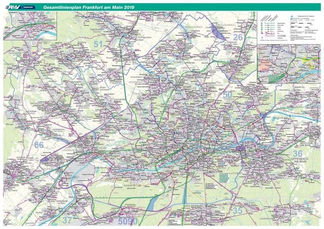
Frankfurt transport map
You can find on this page the Frankfurt transport map to print and to download in PDF. The Frankfurt transportation map presents the transports network and transport zones of the transit of Frankfurt in Germany.
Frankfurt transports map
The Frankfurt transport map shows all means of transportation in Frankfurt. This transports map of Frankfurt will allow you to move easily with public transport of Frankfurt in Germany. The Frankfurt transportation map is downloadable in PDF, printable and free.
Frankfurt is located in the European backbone, a region with particularly dense transports communication routes. Frankfurt transports map has one of the largest railway stations in Europe (Frankfurt Hbf.) within the city walls, supplemented by the airport station. Since June 2007, Frankfurt has been linked to Paris by TGV and ICE (Intercity-Express) trains, which run directly on the Frankfurt-Mannheim Line and partly on the LGV Est Européenne (3.5 hour trip).
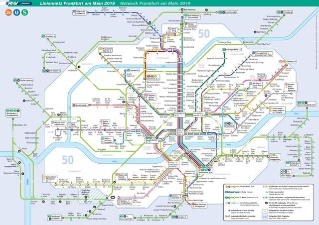
Frankfurt zone map
The Frankfurt zone map shows all transport zones in Frankfurt. This zone map of Frankfurt will allow you to know the prices of public transport of Frankfurt in Germany. The Frankfurt zones of transports map is downloadable in PDF, printable and free.
There are nine combined U-Bahn/tram lines and almost 90 stations in Frankfurt zone map: U1–U3: These lines run from the southern railway station to the north of Frankfurt on one route, then split towards Nordweststadt (U1; red), Bad Homburg-Gonzenheim (U2; light green), and Oberursel (U3; dark purple). U4 (Pink): Runs from western Bockenheimer Warte through the Hauptbahnhof (main train station zone) to eastern Enkheim. U5 (Dark green): This is a combined tram and underground line from northern Preungesheim to the city center of Frankfurt. It shares some underground stations with the U4.